PinnedChristoph RiekeEssential geospatial Python librariesQuick overview of essential Python libraries for working with geospatial data.3 min read·Mar 25, 2018--8--8
Christoph RiekeStart your geospatial careerThis article shares some guidance and resources for starting a career in the geospatial field.8 min read·Aug 22, 2023----
Christoph RiekeQuerying calendar events via the Google Calendar APIDo you want to pull all meetings & events from your or any shared Google calendar via the Google calendar API in Python? This blogpost…4 min read·Aug 29, 2022--1--1
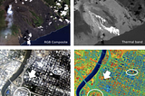
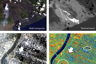
Christoph RiekeThermal imaging with satellitesA short introduction to thermal remote sensing, applications and thermal satellite startups3 min read·Aug 1, 2021--1--1
Christoph RiekeThe best MkDocs plugins and customizationsDiagrams, code reference, notebook integration, macros, pdf generation etc.4 min read·Nov 17, 2020--3--3
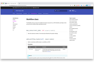
Christoph RiekeDocumenting a Python package via mkdocs-materialHow to create a Python package documentation with code reference via mkdocs-material. Beautiful, simple, powerful, Markdown!4 min read·Aug 22, 2020--4--4
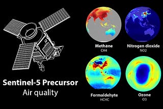
Christoph RiekeinUP42Air pollution: Using Sentinel-5P to monitor the atmosphereAn overview of Sentinel-5P and Level-2 & Level-3 processing explained5 min read·Jan 14, 2020--1--1
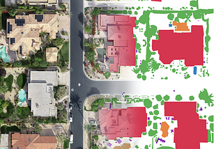
Christoph RiekeTutorial: UAV land cover classification with fastai & Google ColabDronedeploy UAV imagery, fastai and Google Colab. No requirements, in-browser, with a GPU.5 min read·Jan 3, 2020--1--1
Christoph RiekeHowto: Install Python for geospatial applicationsStep for step instructions on setting up Python 3 for Windows with gdal, rasterio, geopandas and other essential geospatial libraries4 min read·Apr 15, 2019--8--8
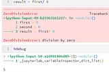
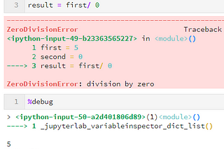
Christoph RiekeJupyter Tips and TricksJust a couple of JupyterLab & Notebook features that I didn’t know a year ago but am now using a lot.3 min read·Aug 12, 2018--3--3